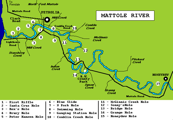

Lighthouse RoadThe first area to be described for the Mattole River is the tidal section. Remember that fishing within 200 yards of the mouth is prohibited and enforced by DFG. At the end of Lighthouse Road is Mattole Beach which offers overnight camping for RVs and trailers good access to the lower lagoon is found from this spot. Wading is necessary to access the entire area with most fish holding up against the north bank. To best fish the area a knowledge of the tides is essential. Lures are the best bet, but during times of low water flies should work in this area as well. Moving upstream a little over a mile on Lighthouse Road is an access road to the river. This road is safe for most vehicles and offers good access to the water. The opposite bank offers the best area in this stretch with pools and runs. First Riffle(1) up to Santa Cruz Hole (2)can be accessed here. Another mile an a half upstream, you come to Mill Creek. There is a dirt road to the water, but it is best to walk down since there is no turnaround. During higher water there is a pond you will need to wade in this area to reach the gravel bar along the river. The immediate area is fairly shallow, but upstream are some deeper holding areas.(3) Rex's Hole. A little over 1/2 mile further upstream is another access point. There is a trail that leads down to the river where there are some good pools. Drury Hole(4) and Peter Hansen Hole(5). Some wading is required to fish these holes properly and during high water you will need to wade to reach this access. Traveling further upstream to the Petrolia bridge, you can access Bridge hole. Park on the Southwest side of the bridge walk down bank to gravel bar and the hole is located under the bridge. This area is productive with lures and at low water flyfishing can be good from just upstream of hole. Clark RoadAcross the river and through Petrolia, head west on Mattole Rd till you cross the North Fork and take a right on Clark Rd to the river. From this area you can access Blue Slide(6) and North Fork Hole(7). A huge gravel bar is located in this area and some excellent opportunities present themselves for both iron slingers and the fly caster. Conklin Creek RoadOn the North side of Petrolia bridge is Conklin Creek Rd that heads East. Traveling East on this road for about 1/2 mile you will come to a trail access leading to the river. There is a berm running along the river here and the trail leads through a depression in the berm. Swimming Hole(8) can be fished from this spot. Wading will probably be necessary in this area for maximum results. Traveling further upstream on Conklin Creek Rd for about a 1/2 mile is a turnout. Following the trail to the river, you will find a nice holding pool with some decent riffles both up and downstream. This spot is just downstream from Gauging Station Hole(9). Traveling to the end of Conklin Creek Road you will find Conklin Creek :). There is a dirt road leading down to the river. This area offers some deep runs and riffles to fish. A little further down stream is Conklin Creek Hole(10). This is a huge hole that usually has fish in it. towards Honeydew Traveling on Mattole Road on the south side of Petrolia bridge for about a mile you will come to Gauging Station Road. This road is blocked by a berm but walking will bring you to the river. There is a nice hole here (9) and some good runs and riffles in the general area. Another mile upstream you will cross a bridge. Bridge Hole (13) is located just down stream from the bridge. Best access is from the downstream end of the bridge to this hole and another just downstream from it. A good deep run is located under the bridge. Traveling further upstream on Mattole Road is A.W. County Park. This area offers up some nice fishing opportunities including Grange Hole(14). Camping, picnicking and water are all available at the park. HoneydewHoneydew Hole(15) is located under the bridge in Honeydew. Access is from the South side of the bridge and some shallow pools and riffles are located just down stream. These are some of the main holes and accesses along the Mattole, as you drive the area you will probably find more. I have attempted to give information that will help you located fish in the river. If you have a fishing experience on the Mattole, please E-mail me your story so I can share it with other visitors to this site. Remember to check for private property and ask permission before trespassing. Also, check DFG regulations before fishing any waters in our state. |
| HOME | LOCAL WEATHER | RIVER REPORTS | |
| Other Fishing Information | |||
| MAD | SMITH | REDWOOD CREEK | |
| VAN DUZEN | EEL | KLAMATH | |
| RUTH LAKE | HUMBOLDT BAY | COAST | |